
1. A Divided Italy
 Click image to enlarge
Questions
A description of the geopolitical situation in Italy on the eve of 1848
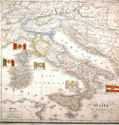
The political map of Italy at the beginning of 1848 shows how the peninsula was largely under the rule of the the Kingdom of the Two Sicilies (Sicily and the whole of Southern Italy up to Gaeta) and the Kingdom of Sardinia (including Piedmont, Liguria and a large portion of Savoy), respectively ruled by the Bourbons (a dynasty of French origins) and the House of Savoy. In the central part of Italy, the Grand Duchy of Tuscany and the Papal State were the most important entities both in territorial and political terms while in Lombardy and the Veneto were under Austrian rule. In the two-year period (1848-49) the situation was completely overturned, the Austrians were momentarily driven out, Rome and Venice had short-lived republican experiences, while the Piedmont came to the fore, raising hopes for a united peninsula. At the end of the First War of Independence the absolute rulers returned and the patriotic movements that had sprung up in Austrian areas were severely repressed, bringing the territorial situation back to what it was before the uprising.


The beginning of the uprising in the Kingdom of the Two Sicilies
In the first days of January 1848, the social and political tensions continued to manifest themselves in a tumultuous fashion. While peaceful public demonstrations in support of the Pope (Pius IX, elected in 1846) and of reform were held in various Italian cities, in Milan the situation seemed to be really on the point of explosion; on the 3rd of January a series of clashes between patriots and Austrian soldiers had resulted in five dead and fifty injured among the civilians.” ( Alberto Mario Banti Il Risorgimento Italiano, Laterza, Roma-Bari, 2009). Surprisingly, the uprising actually broke out at the other end of the peninsula, in Palermo, when, on 12th January, the birthday of King Ferdinand II of Bourbon, an insurrection began (the first in Europe) in which patriotic motives, social unrest and sentiments of opposition to the rulers in Naples where combined in a single protest. The uprising was successful and threatened to spread to the whole of Sicily and so the King, seizing the initiative, announced on 29th January that he wanted to concede a constitution to the Kingdom of the Two Sicilies (this was to be published on 10th February). This wasn’t enough to quell the revolt on the island, where on 2nd February a provisional government was formed in Palermo, but it did contribute to limiting the spread of the protest to the continental part of the kingdom. At this point a chain reaction began on the part of all of the rulers of all of the minor states in Italy who hastened to issue liberal constitutions.