
3. The Greater Region

Questions
Description and Analysis
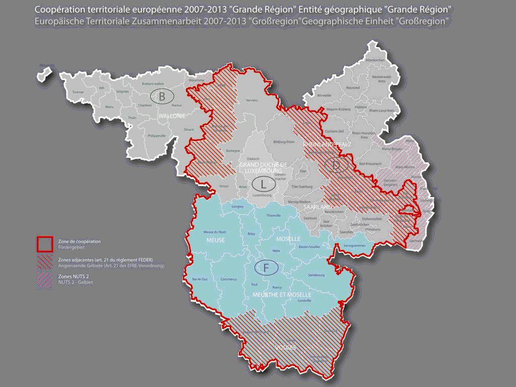
The so-called Grande Région includes Saar (fr. Sarre), Lorraine, Rhine - Palatinate, Wallonia, the French and German-speaking Community of Belgium. Located between the Rhine, the Moselle, Saar and Meuse, has a total area of 65,401 km ². The population is 11.2 million inhabitants.
The Saar (Saarland Sarre in French and in German) is one region created in 1920, after the Versailles, peace treaty, from some German provinces. For 15 years it remained under the League of Nations control, unless, in 1935, it passed to Nazi Germany, with the name of Westmark. Been French after the World War II, it came back to Germany on January 1st 1957 , as consequence of Saar treaty signed by France and Germany on 27th October 1957. Capital city is Saarbrücken.
Lorraine is a French region composed by four departments: Moselle - with Metz as chief town, which is also regional chief town- , Meurthe and Moselle – chief town Nancy, Meuse and Vosges (Vosgi).
Vosges department takes its name from the Vosges mountain chain, going from eastern Reno Valley, from Basilea (CH) to Magonza.
Luxembourg became dukedom in 1354 and, following complex dynastic changes , passing from the Dukes of Burgundy influence to the house of Habsburg. Invaded by Napoleon in 1795, it became Grand Duchy in 1930 as part of the Prussian Confederation. it Became fully independent only in 1867.
Rhineland-Palatinate is a German Land whose capital city is Magonza (german. Meinz).
Wallonia is the French Community of Belgium: Belgium is divided into three regions (Walloon, Flemish and Brussels Capital) and three communities (French, Flemish and German). The Walloon chief town Namur, though Charleroi is more popular both for the massive Italian immigration in the 50’s and the airport, which is served by a low cost airline ensuring connections with several Italian cities and central Europe.
The Belgian German speaking Community is the smallest component of the federal Belgian State. The chief town is Eupen.
The region is at the heart European railway development.
This is a fairly composite space, though basically characterized by the presence of mines and industrial areas that are that are currently on undergoing reconversion. Cross-border cooperation has brought to life common project, as the European Pole for Development of Longwy ( F, in Longwy once it was centered Italian emigration), Rodange (Lux) and Athus (B).
In the northern area (Wallonia and the Rhine valley) there are many big cities and population density is high. The southern area, on the other hand, invece, is part of that low density diagonal characterizing a part of Europe, from central Spain to the east highlands to the Paris basin. Cross-border flows are particularly active, reaching 120,000 workers, of whom 90,000 only from Luxembourg. In the middle there is the cross-border industrial and urban region, including German Saar, French Lorraine and Luxemburg.
Geographical/Historical Context
represents part of the Lotaringian territory including the ancient Duchy of Austrasia. Subsequent partitions divided it in the two areas of influence, the Frankish and Germanic one.
As a Border area since the days of the Roman Empire, The fate of this region between the nineteenth and twentieth century is to be the center of the fighting between France and Germany and to pass alternately from one to another.

Not surprisingly, after World War II, it at the center of the pacification process and European integration.
The ideaof creating a transnational cooperation area, in this very area, was born in the late 60’s within the European economic cooperation context. The German Federal Republic, the Grand Duchy of Luxembourg and France will consolidate the founding Treaty twenty years later, in 1980 in Bonn. the Karlsruhe Agreement in 1996 will give institutional structure for the subsequent development of the Grande Région.
In the Grande Région cooperation is not simply a “cross-border ” one, but it assumes a transnational dimension for it passes national borderlines without implying at any time intergovernmental bilateral agreement
The central States do not come out, however, weakened.for cooperation must take place within the respective national legal frameworks. Nevertheless, as fare cooperation depends for the most European funds (INTERREG program), regions with strong legislative powers - the German and Belgian regions land – may have independent financial resources that make them stronger in their states. In fact, France, the most centralized state of the four, had initially demanded for the cooperation within bilateral intergovernmental happen.
The cooperation involves both the economic field, in particular infrastructure, building and the educational and social one. Reports of the early Euroregion summits, insisted especially on the urgency of building a eastern branch of the TGV North, that is to say the route Brussels - Liège - Cologne, as well as the completions and highways linking the Saar capital with Luxembourg, Liège Rheinböhen and connection with the B69/RN33 the Paris-Strasbourg.
In 2009 the creation of a GIS of the Grande Région was decided, which helps the regional development and planning. It is a system for collecting, processing, organizing and presenting data which allows for an space analysis and insight. Data covers urbanization, demography, transport and mobility across borders.
At a educational and cultural level, la Grande Région has developed a series of Community programs, including a map for university cooperation, a high school in Germany and Luxembourg, a choir and a musical cooperation, a cultural portal.
with regards to the social area, there is a long tradition of trade union cooperation.


Presentation
The first map indicates of which region the Euro Region known as Grande Région, in French, o Großregion, in German, is composed. This is a very wide area which includes France, Belgium, Luxemburg e Germany, a area that has always been in unstable balance between France and Germany. As the centre of two world wars, it represents the heart of the European project of peace and cooperation. This region, at the end of shared of World War II, shared the features of an economical growth which was mainly linked to mining industry. Now it is to share the industrial reconversion, due to the decrease in this area.
The French-German bilingualism is widely spread and the cross-border mobility is high.