
1. Those excluded from urbanization, the Zone
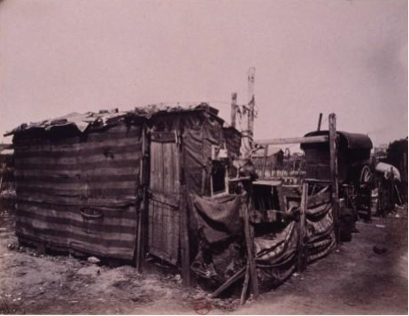
1a. A photograph by Eugène Atget, Zoniers. Porte de Montreuil (20th district), 1913
 Click image to enlarge
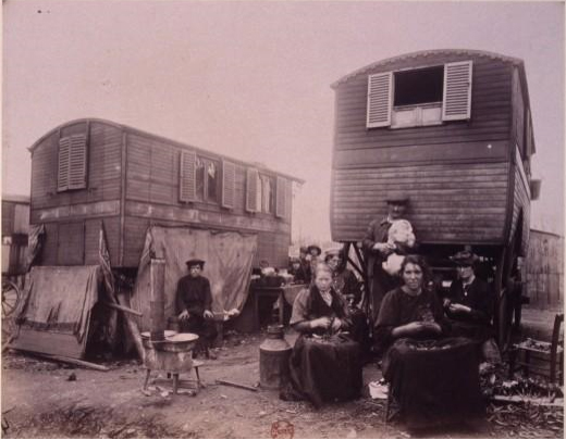
1b. A photograph by Eugène Atget, Zoniers. Porte d’Italie, 1913.
 Click image to enlarge
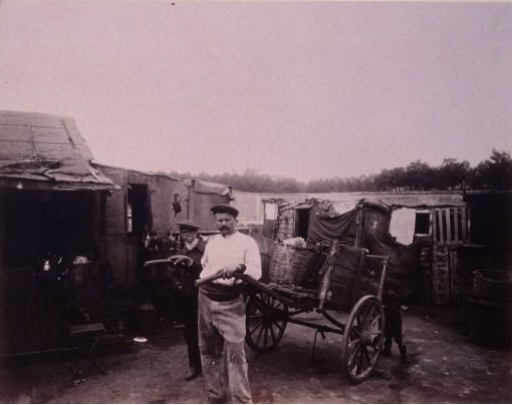
1c. A photograph by Eugène Atget, Poterne des Peupliers: zoniers (13th district), 1913
 Click image to enlarge
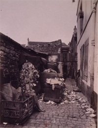
1d. A photograph by Eugène Atget, Cité Doré. 70, Boulevard de la Gare: 13th district, 1900
 Click image to enlarge
Questions
Historical context and analysis
Despite the modern fame of the photographic albums of Eugène Atget, especially after the major retrospective organized by the Bibliothèque Nationale de France in 2007, we know little about his life. Atget was born in Libourne on 12 February 1857; he died in Paris in 1927. For some time, he might have been a sailor. Then, he pursued an acting career. Though Atget eventually abandoned the stage, theatre remained in the center of his interests; he even gave lectures in this field. By 1890, he started creating photographic portfolios for artists. Afterwards, in the years 1897-1898, Atget took photographs of old Parisian districts that were to disappear and small businesses condemned to oblivion by the rise of department stores, and gathered his photographs in an album. Now the series of his photographs are the property of various French and foreign institutions whose collections are mostly accessible on the web (Bibliothèque Nationale de France, MoMA, George Eastman House, Musée Carnavalet, Historical Library of the City of Paris, heritage photographic archives...). The presented photographs of the Zone have been taken from the album entitled “Les Zoniers”. The 60 photographs, whose negatives date back to the period 1899-1913, are available at the BnF website: (http://gallica.bnf.fr/ark:/12148/btv1b3100004z.r=Eug%C3%A8ne+Atget.langFR).
Throughout his life as a photographer, Eugene Atget used an old-fashioned technique: a wooden bellows camera 18 x 24, fitted with a lens that corrects spherical aberration (the so-called rectilinear lens), visible on some photographs. As negatives, he used sensitized glass gelatin-bromide plates. He printed his photographs on albumen paper – at the end of his life, he used photo-sensitive silver gelatin-chloride paper, the Aristotype paper – on which prints were made by direct contact of the exposed frame to natural light. These choices had consequences for both the quality and the great finesse of photographs. The exposure time was long. This made snapshots – the stolen pictures– impossible since moving subjects appeared as transparent or blurred shadows. Atget’s “zoniers” knew that their photographs were taken; some even posed for them. In the absence of written details on the photographs taken on the outskirts of Paris, we may make some assumptions about the relationship between the photographer and the subject, in particular as regards the texts that highlight the “zoniers’” pride and the dangerousness of the Zone.
From a strictly topographic point of view, the area covered the “fortified military zone”, non aedificandi, introduced in 1841 and decommissioned by the Act of April 19, 1919. It was located in the vicinity of the walls with old battlement and glacis that surrounded Paris and were to be demolished(some vestiges of the walls can be found in Poterne des Peupliers (”Postern of the Poplars”) and in Kellermann Park in the 13th district and at Porte de Bercy in the 12th district). Now this corresponds roughly to the area between the boulevards of the marshals and the ring road. The protection of Paris was a widely discussed topic in the early 19th century until the creation of a Defence Committee of the Kingdom by Adolphe Thiers’ government in 1836. In its final report issued in 1839, the Committee postulated building a continuous wall and a line of forts. Declared as public utility, the project was voted in 1841, despite numerous opponents:
“I reject this insane project. The power of France does not reside in the walls of Paris: its strength is in its people, its soldiers. What troubles us is that we cannot feed or provide accommodation for 500,000 inhabitants of the city, that Paris is besieged and the French government overthrown! What is it then for Europe? Surrender before the battle. No mistake! 500 million for this? It’s too foolish to be true and too expensive to be a lie. I reject (the project) in the name of common sense, dignity, humanity and freedom of my country” Alphonse de Lamartine, Le moniteur, 22 January 1841.
The 128-meter-wide fortifications built between 1840 and 1845, surrounded Paris, annexing many bordering communes (Belleville, Grenelle, Charonne, Vaugirard, Montmartre, Bercy, Les Batignolles, Passy, La Chapelle, Ivry, Auteuil, Montrouge). The fortifications consisted of a 6-meter-wide road, a double wall with a gap of 40m, a counterscarp, a glacis, which became the border of Paris on 1 January 1860, and 65 openings (doors, gates, posterns, railway gates, canals). Having quickly become “the classic walk of the working people and petty bourgeois” (Emile Zola, Le messager de l’Europe, 1878), the non aedificandi zone was transformed after the 1870 war into a commune of refreshment. It attracted scavengers and hosted flea markets. According to various estimations made before 1914, the population consisted of 30 000 to 200 000 inhabitants:
“Currently, there are 12,132 constructions of various kinds in the military zone; more than a half them, precisely 6,805, are only wooden huts or gypsum cabins - worthless and mostly uninhabited, 3,134 buildings are made of impermanent materials and without gas safety precarious; of the remaining 2,193 buildings, 966 were detached houses, 932 buildings were intended for industrial or commercial purposes; of the remaining 295apartment houses, 130 had more than three floors.” Louis Dausset’s report on decommissioning of the fortifications, the annexation of the military zone, and the draft agreement between the City of Paris and the State of Paris, 1912, p. 25, quoted by Jean-Louis Cohen, Lortie André, Des Fortifs au Périf. Paris, les seuils de la ville, catalogue de l’exposition, Paris, Éditions du Pavillon de l’Arsenal, 1991, p. 67.
Taken in various locations around Paris, Eugene Atget’s photographs show different aspects of the community of ragpickers and their living conditions, permanent houses, shacks made of planks and trailers. Other photographs from the album, available on the BnF website, can give you an idea of the topography of the place. These four photographs and the whole album had a strong resonance in the media. They were published together with commentaries which stressed positive feelings and to a smaller or greater extent concealed the problem of the rejection of the marginalized population. The photographs were also accompanied with comments on of the dangerousness and morbidity of the zoniers as well as the cost the society has to pay to provide for the community of people who “benefited” from undue allowances and political and media debates showing the competition between political authorities or social and health institutions and charities, not always concerned about the precarious status of these people.
Answers
- The photographs were taken in the area of military fortifications of Paris where numerous refreshment bars frequented by the Parisians on Saturdays were located. After the 1870 war, this area was populated mostly by social outcasts such as scavengers. This military zone was decommissioned in 1919, it is now occupied by the boulevards of the marshals, low-income housing estates built in the 30s, some stadiums and ring roads.
- Apart from concrete buildings erected outside the urban part of Paris, the housing in the Zone was dominated by huts of wood, drywall, sheet metal and cardboard as well as trailers.
- The two photographs show the activity of scavengers who salvage all the Parisian old papers, rags and useful objects they later sell by weight or at flea markets.
- Eugene Atget used a wooden bellows camera and a glass plate 18 x 24 negative. The camera was heavy and time consuming to install. The exposure time was important. The photographer could take a picture only if the subjects agreed to pose. Moving people were not captured in photographs or left only a small trace. Viewing the online collection of the BnF, one can notice some photographs of Atget which show his photographic chamber and many photographs where moving people resemble ghosts. See « Le sujet dans l’objet » (http://classes.bnf.fr/atget/pistes/04.htm ) and « L’acte et le geste photographiques » (http://classes.bnf.fr/atget/pistes/05.htm ) in educational materials in the Atget virtual exhibition, Regards sur la ville of the BnF (http://classes.bnf.fr/atget/index.htm ).


Presentation
These four photographs, which are a part of an album of 60 photographs of "Les zoniers", were made on a glass plate negative and printed on paper by Eugene Atget (1857-1927). The technique used by Eugene Atget requires long exposure. The photographed people must stand still. The photographs were taken in the area of military fortifications surrounding Paris since 1841, where all the people who could not afford housing in Paris and the surrounding towns gathered. Some residents of “la Zone”, such as junk dealers, used to practice small trades; they salvaged and resold old and useless papers and rags.