
3. Case studies of borders
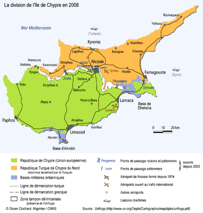
3a. Cyprus division in 2008
 Click image to enlarge
Présentation
The island of Cyprus is a good example for those who wonder if this land is European or not. Its location near Turkey and the Middle East would logically suggest that it belongs to Asia. However, historically, culturally and politically, Cyprus has become closer to Europe. Whether under Richard the Lion Heart, under the rule of the Venetians, of Byzantium, of the Frankish king Guy of Lusignan, or even under the Ottoman and then the British Empires, the Greek heritage has always survived in Cyprus together with a strong sense of belonging to Greece. The attachment to this country was the root of the civil war between Greek Cypriots and Turkish Cypriots, which led to the division of the island in two parts.
If the majority of the Greek-speaking population in the Republic of Cyprus now inhabit the south of the island - the only state that have been recognized by the international community – the north of the island is mostly inhabited by a Turkish-speaking population under the authority of a State which has been recognized only by Turkey.
However, the two communities claim they are European and we may notice that, while in secondary school geography textbooks of the past maps of Europe were not often large enough to include Cyprus, since its entry to the European Union, the maps of Europe have been systematically extended eastward to do so.
Questions 3a
3b. The Bosphorus
 Click image to enlarge
Présentation
The possible entry of Turkey to the European Union calls into question this traditional boundary between Asia and Europe. It is a true topographical or geographical bound or is it a cultural and economic boundary? What does it represent?
The answer is complex because the space on either side of the strait has been shaped by the Greek, the Roman, the Byzantine and the Ottoman powers. . The Greek influence increased together with the influence of the Byzantine Empire while, in the Ottoman period, the Empire spread its culture and religion in the European regions it occupied, especially in Bosnia-Herzegovina and Albania.
The city of Istanbul preserves visible traces of all these historical and cultural strata. The Bosphorus Strait is a "natural avenue" which brings together and, at the same time, facilitates the multiple internal diversification of the huge metropolitan area, whose "European side" appears more historical and attractive for tourists, while the "Asian side” accommodates modern economic activities which this city needs to sustain its abundant population.
Questions 3b
3c. The Strait of Gibraltar
 Click image to enlarge
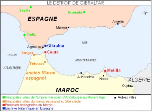
(Key to the map)
- Main towns of the Moroccan Empire of Andalusia in the Middle Ages.
- Main towns of Spanish Morocco in the twentieth century.
- Spanish enclaves in Morocco.
- British enclave in Spain.
- Other towns.
Presentation
In the geographical landscape, the Strait of Gibraltar clearly marks the borderline between Africa and Europe, Yet examining these shores, it is possible to point to the fact that the Maghreb has nothing to do with the European culture. Indeed, the western part of North Africa was the subject of the Reconquista after the resumption of Granada in 1492. This explains, even today, the Spanish status of the enclaves of Ceuta or Melilla. As for Andalucia, Algarve and northern Morocco, these areas retain many common features. The close links between them result nor only from their original names and many mixed marriages between the three communities (Christian, Jewish and Arab), but also from the fact of living under the protection of Moroccan dynasties in the days of Al Andalus until 1492.
But history also keeps the memory, even of more distant events, such as the remains of the brilliant Roman civilization which settled permanently in the south of the Mediterranean area after the destruction of Carthage. It will not be necessary to go back to those mysterious Iberians, whose descendants eventually became Spanish, Portuguese and Berber, to understand that North Africa, as "the cradle of Latin Christians", has been considered by anthropologists of the twentieth century as a part of “anthropological Europe". You can find in this one of the many reasons that led Morocco to apply for a membership in the European Union in 1984.
Questions
Suggestion of Activities
- Examination and comparison of some contemporary border situations.
- Further considerations concerning the typology of borders.
The Strait of Gibraltar exemplifies the case of an intercontinental border apparently formed by nature. Yet, it is more complex than it appears because one could find traces of the influence of other political powers on both sides of the strait in the past (Kingdoms of Cordoba and Granada or the Spanish colonization of Morocco).
However, the situation in Cyprus shows that the existence on the borders of Europe and Asia may lead to an explosive situation between two European countries with historically tense relations, particularly for religious reasons.


(Key to the map)