
1. Vienna around 1800 and its cityscape today – a comparison

Source: Bird’s Eye View of the city of Vienna by Daniel Huber 1778, Wien Museum in: Hausner, E. Wien P. 17, Vienna 2009.
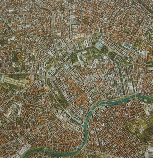
Source: Geospace Satellite image in: Hausner, E. Wien P. 12. Vienna 2009.
Questions
Description and Analysis
In the years 1857 and 1858 the fortifications that had been built to protect the inner city were demolished. Following this the glacis was built upon – in its place the ring road and parks were constructed. The former suburbs which lay outside today’s Ring Road were incorporated into the city. This is how the first nine districts which lay inside the former outer fortification, the Linienwall, (today’s Gürtel) came into being.
Answers to the Questions
- The Danube canal, parks on the former glacis (free land), fortification, the suburb outside of the ring road.
- The former glacis is used today for magnificent buildings and parks.
- The Ring Road is in the north west of the Danube canal and can be recognised by its straight course and dark green colour.


Presentation
The section of the map on the left shows the inner part of the city of Vienna around 1800. The fortifications of the inner city, the adjacent unbuilt artificial slope outside the city walls (glacis) and the suburbs are all clearly visible. Coming from the west, the Danube and its canal can also be clearly seen.
Taken on the same scale in 2000, the satellite image on the right shows the inner city and the surrounding districts (former suburbs). Parts of the formerly vacant land (glacis) have become parks or have been built upon. Vienna’s river and the former branch of the Danube are heavily regulated.