
5. Other exemples of euroregions across the Italian borders: Euroregion without borders (Villa Manin), Tirolo - Alto Adige - Trento, Working Community ALPE ADRIA
 Click image to enlarge
 Click image to enlarge
 Click image to enlarge
Questions
Description and Analysis
The “Borderless Euroregion” as well as the Alps-Mediterranean euro region is an EGCC, which means a public law organism, whose statute and dutieshave been decided by laws of each State.
The Alps-Adrian Working Community, unlike the EGCC, does not have a legal status limiting its operative level. Its territory is significantly wider than that of an EGCC.
Geographical/Historical Context
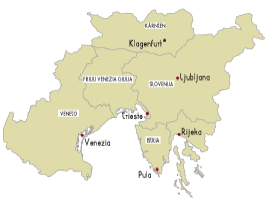
Borderless Euro region (Villa Manin)
The Euro region duties are to be found in the DGRV (Resolution of Veneto region) art. 6, 1212 /2010 and consist in encouraging an affordable, balanced and long-lasting development, as well as a economical, social and cultural integration and cohesion of citizens, as stated in art. 4, in the perspective of strengthening the cohesion between the citizens and territories, and the competitiveness of the whole area.
Order to achieve the purposes referred to in paragraph 1 the EGCC it identifies and implements a common strategy concerning the 'harmonization of economic and social development of the territory, use and conservation of natural resources, the coordinated development of physical infrastructure system ,intangible assets and logistics ,innovation promotion.
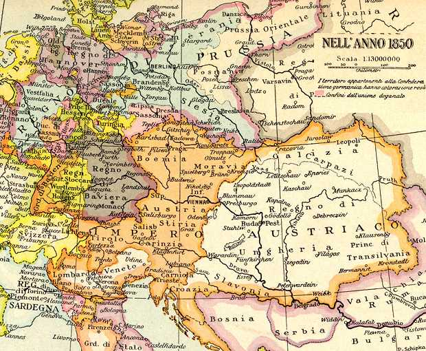
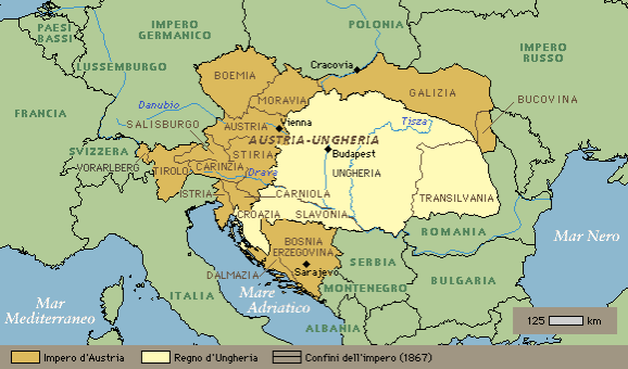
The Euroregion area includes an area during the 19th Century , was under the Habsburg government control. Veneto, in 1814, became part of the newborn Reing of Lombardo-Veneto, devised by Chancellor Metternich, while settling down European borderlines during the Wien Congress. Veneto shall be ruled by Austria until 1866, the date of its annexation to the Reign of Italy.
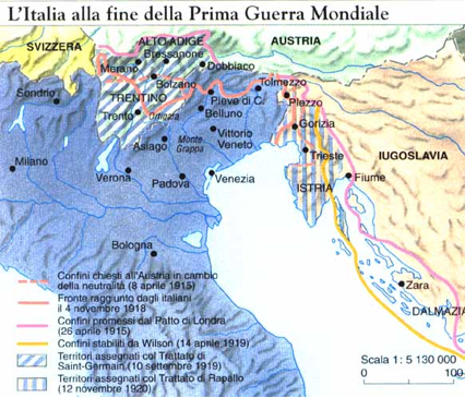
The territory known as Trentino-Alto Adige has always been part of Tyrol, a region almost incessantly belonging to Habsburgs until 1918. during Napoleonic conquests Its boundaries underwent changes, when the region was split between Austria, Bavaria and that Kingdom of Italy created by Napoleon. This epoch while the term Tyrol was created (Haut-Adige), and it mainly stood for however, Trentino. In 1813, the entire area went back under Austrian control. It was only after World War I that Italy, by virtue of the London Agreement, could annex the territory up to San Candido valley, which corresponds with the Alpine watershed.
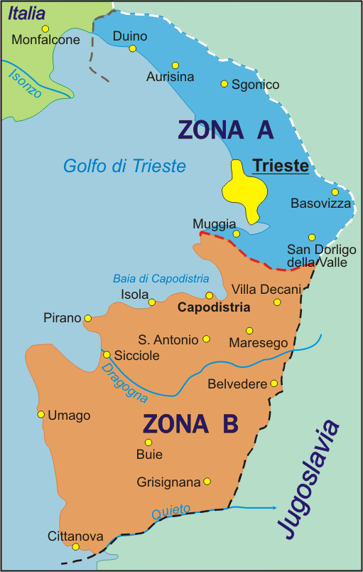
Slovenia also has always been a Habsburg stronghold, until Illyrian Provinces were created by Napoleon. That was a short experience, quickly ending with the return of the Habsburgs in 1813. After the First World War, the western part was annexed to the Kingdom of Italy, with the name Venezia-Giulia and passed to the Yugoslav Republic in 1945, at the end of World War II.
Although not yet included in the EGCC - as it is still not so far what remains of Slovenia - The Istrian region taking part to the co-operation, followed the events. until 1797, Veneto Region, when Napoleon, with Campoformio Treaty, gave the whole Serenissima territory to Austria, was spitted in two between the Kingdom of Italy and Yugoslavia after the First World War. It entirely passed to Yugoslavia after Italian defeat in World War II.
The City of Trieste, (which should have been the "capital" of the Euroregion, at the end of World War II) was briefly occupied by the Yugoslav army. On 12th June 1945 it passed under Allied control. By the way, the matter was resolved only in Trieste in 1954 with the London Memorandum, signed by the United States, United Kingdom, Italy and Yugoslavia.
 Click image to enlarge
 Click image to enlarge
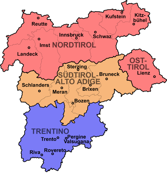
Euregion Tyrol, Alto Adige, Trento
The partnership linking the three communities concerns the economy, transport (tunnel project under Brenner Pass), research (joint actions of the three Universities), culture (for instance, the great historic Landesausstellung 2000 exibition) , education and training (bilingual classes) , environment, tourism, communications and other social issues.
Among the Euroregion main aims, is to promote a sustainable development context, by taking into account natural and environmental Alpine region conditions as well as its particular sensitivity. The intervention safeguarding the alpine regions interests and their people’s - as agreed in the Alps Manifesto of , in St. Michael-in- Adige, in Trento province, January 26th, 2001 - expresses an action based upon the subsidiary principle . Such an assumption seeks to assign Alpine region inhabitants of the - and therefore not to external subjects -to manage their territory.
"Terra in montibus" in Latin or "Land im Gebirge" in German: until First World War eve, these were the ancient names of the wide geographic area which included, not only the eponymous Austrian Land (Nordtirol), but also South Tyrol (Mitteltirol) and Trentino (Southern Tyrol, a name passed to the territory of Bolzano, later on). This is a land that experienced some the independent principalities rises: Trent and Brixen bishoprics , the long relationship with the Counts of Tyrol, all the same, first and that with the house of Habsburg, Emperor Maximilian’s Land Libelle, then.
 Click image to enlarge
 Click image to enlarge
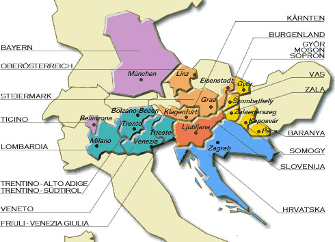
Alpine-Adrian Working Community
The earlier regional institutions that became part of this community were Baviera (Germany); Friuli-Venezia Giulia and Veneto (Italy); Carinthia, high Austria, Stiria e Salzburg region (Austria); Slovenia e Croatia (once part of Yugoslavia, today indipendent). Since that time, also Hungarian provinces of Baranya, Somogy, Vas and Zala, Lombardy as well as Austrian provinces of Burgenland adjoined. However the latter is no longer part of Salzburg region. Besides the interest for area environmental, the regions composing Alpine-Adrian region are likely to discuss together some issues concerningto regional planning and environmental protection. Even in this case, it comes, for the most, to to territories (except for Bavaria) having a shared past within the Austro-Hungarian Empire.
 Click image to enlarge
The following excerpts are taken from the site of the Community and describe some regions that are less-known to the Italian student
Vas County(HU) it has a nice geographical position. Confining with two stranger countries. Austria and Slovenia, has inner borders linking Vas to Veszprém, Györ-Moson-Sopron and Zala counties. After Iron Curtain’s fall, this region could take advantage of some new benefits related to its strategic position. By the way, 2.5% of inhabitants are not of Hungarians: they are Croats, Slovenes, Germans and there is also a Rom minority.
Baranya County (HU) as the southern county of Hungary, it has rivers Danube and Drava as natural borders. Its territory, with 402.000 inhabitants, is 4487,4 km2. The eastern borderline touches Bács-Kiskun County, the southern Croatia. economic-social, cultural and intellectual centre of South-Transdanube area is the town of Pécs, with about 160.000 inhabitants.
Burgenland (A) is the most eastern and also the "youngest" Land of Austria. With an approximately 4000 m2 area, it has Eisenstadt as regional capital. At the Lake Neusiedl region heart, there is the only steppe lake in Central Europe. The famous Natural Park which stretching over both Austrian and Hungarian territories, straddling the two borders, has a true cross-border value.
Links
- Borderless Euroregion: http://www.regione.veneto.it/NR/rdonlyres/B8401ED1-2477-4492-B4BC-276A89077B9B/0/percorsoEuroregione1_4_10.pdf
- Euroregion Tyrol, Alto Adige, Trento: http://www.europaregion.info/it/
- Alpine-Adrian: http://www.alpeadria.org


Presentation
Borderless Euro region - the project of constituting a unique euro region, which might include the High Adriatic area, starts in 2005 and comes true on 17th November 2009 with a mission statement signed by Veneto, Friuli Venezia-Giulia, Carinzia and Croatian counties of Istria e and Coast-Mountain. The way this euro region is often known as, Villa Manin, got its name from Passariano mansion, located nearby Udine, where both the mission statement and the collaboration agreement were signed, respectively in 2005 and 2009. In the EGCC – which is also known as “borderless Euro region” the are at the moment only Carinzia and two Italian regions. (Austria approved the EGCC with the Kärntner EVTZ Gesetz law, on 18th December 2008, while Italy took action with act n°88, of July 7, 2009). Cooperation with Slovenia and the two other Croatian regions is still going but still it has been not made official within the EGCC.
Euro region Tyrol -Alto Adige/ Trento – the project of creating this euro region – including a area that has always been historically united and of German-speaking language – began in 1991 with a resolution of legislative assemblies of Bolzano, Tyrol, Trento and Vorarlberg for a better cross-border cooperation.
Two year later, on 2nd June 1993, the same subjects gathered in a meeting session in Innsbruck and deliberated for a interregional and cross-border cooperation of local authority. This turned out, in 1998, into a cooperation deal, within the same euro region framework. The most important document is represented by the so-called “Manifesto of Alps”, 2001, where the following targets were set: “tangible objectives and measures to be taken in agriculture and forestry, nature protection, tourism, companies settlement, transport, education, training, research and culture by formulating at the same time the principles for their implementation.”
Alpe Adria - The Alps-Adriatic Working Community was founded on 20 November 1978 in Venice by Bavaria, Friuli-Venezia Giulia, Carinthia, Croatia, Upper Austria, Salzburg (an active observer), Slovenia, Styria and Veneto.
The "agreement protocol" created an organization with clearly defined tasks and objectives.
At the present moment, the Alps-Adrian Working Community has got 10 members: Baranya, Burgenland, Friuli-Venezia Giulia, Carinthia, Croatia, England, Slovenia, Styria, Vas, Veneto. The Alps-Adriatic territory covers an area of 172,405 km ² and it is a home country for nearly 24.3 million inhabitants. Data were gathered from the community site, which is little different comparing to those sorted by Wikipedia (190,423 km ² for about 26 million people).